Continuous waveform recording from a newly established broadband seismic network in Saudi Arabia, in addition to data produced by other stations in the region, were used to map regional seismic wave propagation (Lg and Sn) and Pn attenuation. Moreover, crustal thickness in the Arabian plate was also estimated based on receiver function analysis.
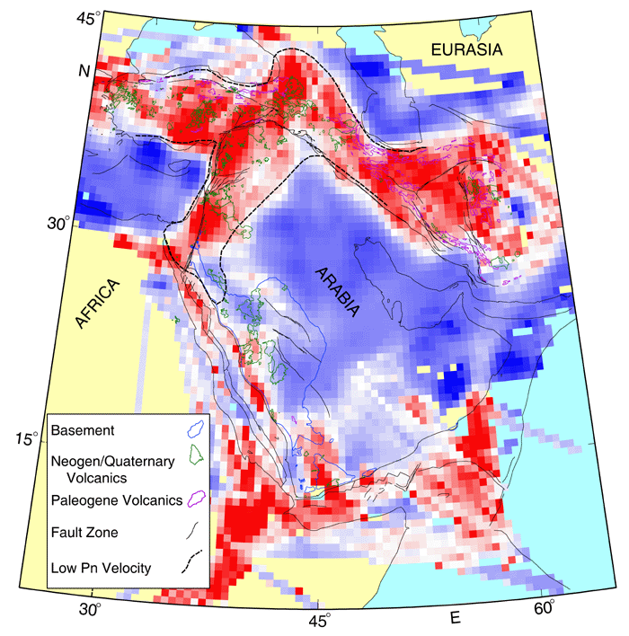
Zone blockage and inefficient Sn propagation is observed along and to the east of the Dead Sea fault system and in the northern portion of the Arabian plate (south of the Bitlis suture)., We observed Sn blockage across some segments of the Red Sea. These regions of high Sn attenuation have anomalously hot and possibly thin lithospheric mantle (i.e., mantle lid). Consistent with our Sn attenuation findings, we also observed low Qpn along the western portion of the Arabian plate and along the Dead Sea fault system. Our results imply the presence of a major anomalously hot and thinned lithosphere in these regions that may be caused by the extensive upper mantle anomaly that appears to span most of east Africa and western Arabia. These mapped zones of high attenuation closely coincide with an extensive Neogene and Quaternary volcanic activity.
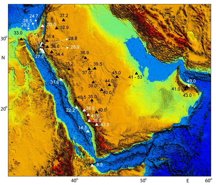
We found that the average crustal thickness of the Arabian shield is 39 km. The crust thins to about 23 km along the Red Sea coast and to about 25 km along the Gulf of Aqaba. We observed a dramatic change in crustal thickness between the topographic escarpment of the Arabian shield and the shorelines of the Red Sea. We compared our results in the Arabian shield to nine other Proterozoic and Archean shields that include reasonably well-determined Moho depths. We do not observe a significant difference between Proterozoic and Archean crustal thickness. Our observations show that the transition from oceanic to continental crust along the Red Sea margin occurs over a relatively short distance compared to a typical west Atlantic continental margin.
We argue that the anomalous nature of the Red Sea margin may be one of the consequences of the presence of a mega plume that extends from the core-mantle boundary into the upper mantle beneath east Africa, the Red Sea, and the western portion of the Arabian plate. In addition, the site where the sea-floor spreading of the Red Sea occurred was a Proterozoic suture and a zone of weakness. These observations combined may explain the relatively abrupt breakup of the Arabian plate and the anomalous nature of the Red Sea margin.
Click here to view a PDF file of the complete dissertation
Figure 1.16.
Map showing Sn tomographic model overlain by the tectonic map of the region and the Pn contour lines corresponding to low Pn velocity (Al-Lazki et al. 2004). Regions of high Sn attenuation correlate well with regions of low Pn velocities. Also, regions of Sn attenuation correlates with regions of Cenozoic volcanics. See Figure 1.8b (see dissertation) for explanation of color-coded bar for Sn efficiency.

Figure 2.12.
Moho depth results with error estimates for the 36 stations shown in Figure 2.2 (see dissertation) plotted over a topography map. The thickest crust is along the Arabian shield escarpment. Thinner crust was observed along the Red Sea coast and Gulf of Aqaba. A dramatic change in Moho depth between stations along the Arabian shield escarpment and stations along the Red Sea coastline can be observed.
